If you were to perform a quick google search to look for fire service thermal cameras, you’ll quickly get inundated with images and articles of thermal cameras being used in the urban firefighting environment. To any outsider, you could understand how they could almost be led to think that these cameras are exclusive to the realm of structure firefighting. We know that thermal cameras come in all shapes and sizes, and perform a wide range of tasks to aid the firefighter and incident management teams. The question to ask is, does a thermal imaging have a valid place on the fire-ground of a wildfire incident?
With technology advancements moving at speeds like never before, combined with lower development costs, thermal cameras are beginning to emerge into the firefighters toolbox a little more every time a fire season passes. Simply rewind 30 years ago and it would be rare to see a wildfire being observed using thermal cameras from an aircraft, now it’s almost built into any large incident response model. The information revealed is invaluable to gain a full perspective of the fire at hand.
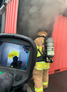
By giving ground crews with this same technology, you are enabling them to be able to see more, which will not only improve crew efficiencies during suppression and overhaul activities, but more importantly dramatically improve the safety of these individuals that willingly put their hand up to perform some of the most labour intensive activities in the harshest environments. One cost effective solution to improve crew capabilities is to equip ground crews with handheld thermal cameras. There are essentially two different types of firefighting thermal cameras accepted today, situational awareness cameras and decision making or tactical cameras.
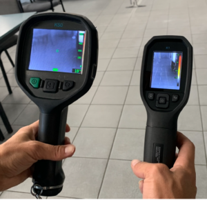
Situational awareness cameras are designed to improve operator safety simply by allowing them to see more of their surroundings and be able to identify any immediate hazards present. Due to the low purchasing costs of these cameras(~$1000), it could be expected that there would be trade offs that come with them. Generally these cameras come with reduced features, screen sizes are smaller than their tactical camera counterparts, and finally the resolution and sensitivity of the detector is greatly reduced. While these attributes restrict the operators ability to rely on the camera during searches, they are still able to be used to compliment existing search techniques. However, no thermal imaging camera should be used alone for a search, crews should use a combination of search techniques.
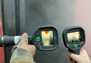
Decision making or tactical cameras on the other hand start to become a considerable financial consideration. They do cost significantly more than the mentioned situational awareness cameras, however the operating performance they have greatly enhances the confidence of the operator. Resolution and refresh rate is dramatically improved, as is the detector sensitivity. Put together this means that smaller details can begin to be made out and residual heat can be detected for longer periods. Searches can start to really benefit more from the camera (but still not to replace existing techniques), hazards and areas of interest will be displayed more prominently. We know that equipping ground crews with thermal cameras won’t eliminate the risks of personnel and vehicles colliding, simply by being allowing all crews, ground or vehicular to able to see hazards at greater distances, and then providing more time to recognise and react, you’ll dramatically improve safety during wild fire incidents. As car manufacturers are moving deeper into integrating automated navigation functions, the same thermal technology is being implemented into the smarts of these cars. These advanced cars can literally see the world in infrared.
Which now creates the question, is there a place for thermal cameras to be equipped onto fire suppression vehicles?
There are numerous retrofit aftermarket camera systems that can be installed cost effectively as well as easily to these types of vehicles. Operating a heavy vehicle in rugged terrain while moving about in almost zero visibility while at the same time ground personnel are undertaking their tasks is a huge risk. Having a simple set of events that on their own would be of little significance, but when combined can be catastrophic. Consider a firefighter that is working along a fire break, fire suppression vehicles are moving back and forth the same trail. All it would take is for a change in direction of the smoke and the firefighter may experience vision and respiratory discomfort and move backward away from the smoke.
At the same time, a suppression vehicle moves along the path when the smoke change now renders their visibility to almost zero. The driver is unable to see the firefighter, and the firefighter is too preoccupied trying to move away from the smoke. This hypothetical example has probably almost played out many times. To bring a different perspective to the incident, having a set of eyes in the sky is always going to add benefits to the incident management team. Improved crew accountability, increasing crew efficiency by being able to place appropriate resources where they’re needed to name a few. Adding thermal imagery to the aircraft payloads will further enhance the information available. Identify hotspots and be able to accurately prioritise areas needing suppression crews or water bombing assets are just a few of the reasons departments should consider putting thermal technology in the air.
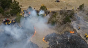
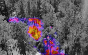
(Photo credit Nine Ten Drones)
By recording flight data and video, whether it be it visual or thermal, and then documenting this for review at a later time can provide opportunities to reflect and analyse that may not appear during the incidents duration. It’s these times that we can really apply time and see the incident and scene through some analytical perspective and develop future tactics and response models. sUAS aircraft are becoming cheaper and more readily available than traditional aircraft platforms such as rotary wing and fixed wing aircrafts. This availability should enable an incident to have multiples of these systems airborne to provide multiple perspectives.
Artificial intelligence is beginning to make its way deeper into these systems, enabling functions that would have been previously been extremely difficult or time intensive. Functions such as plotting way points and having the aircraft cycle through points of interest and frame the image exactly the same each time in one example. This ability, combined with the remote streaming abilities really starts to bring to the table a new set of tools and information streams to the incident management team.
During the wildfire season in the US 2021, a number of fixed thermal cameras were deployed by forestry management to various elevated positions, which allowed for the provision of thermal imaging of the fire front in all lighting conditions as well as allow for the detection of any spot fires that occur ahead of the fire front. When these sentry type systems were live streamed, it that up new unique opportunities for the community to develop their own situational awareness of the fire conditions as well as allow for public to alert authorities if they identified any new or changed conditions.
The constant research and breakthroughs occurring in the fields of artificial intelligence will no doubt make their way into how forestry fires are predicted and managed. There are numerous software solutions in use today that collate and analyse both environmental conditions as well as current dire conditions to provide accurate and valuable fire predictions. There would be no doubt images and measurements fed in to an AI system from either airborne or ground based thermal imaging systems can further add to accuracy of predictions.
From how far in recent years fire services have recognised and leveraged new technology and incorporated it into both prevention and response models when it comes to combating wild fire incidents is truly inspiring. What develops in the future and how it too fits into the toolbox of incident management teams is exciting. Just think about the evolution of drone technology and the added capabilities it’s provided while simultaneously reducing human and financial resources to achieve objectives. We now have a truly new dimension on how we see, understand and and tactically respond to these complex and difficult incidents.
Instructor John Black
If you would like to learn more about this subject.
Check out our FREE Decision Making Drone Use Webinar Series sponsored by Foxfury Lighting Solutions, Nine Ten Drones, and FLIR
